Some rules of hydrology are made to be broken. Two such infractions occur at junctions along rivers in Venezuela and Suriname, where the water flows in unexpected ways.
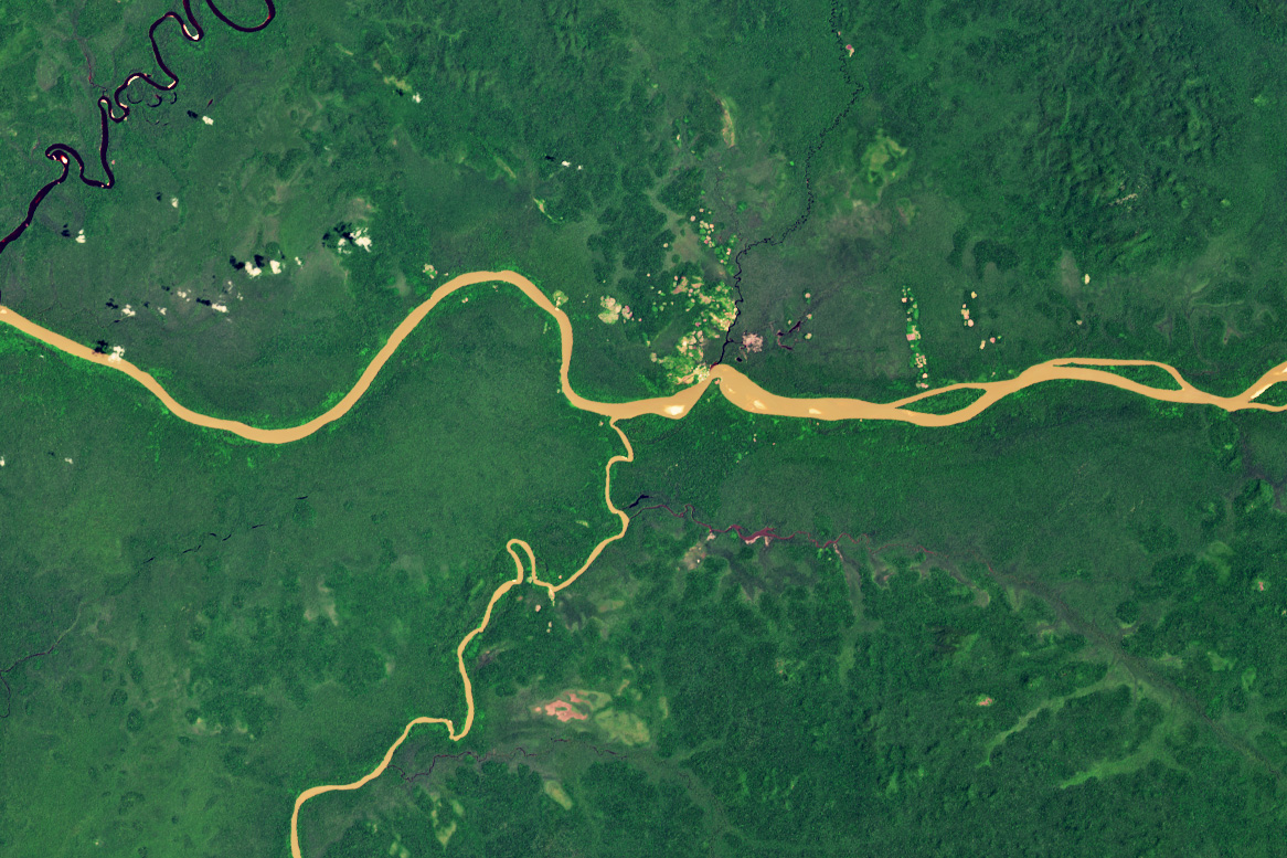
In Venezuela’s Amazonas state, the Río Casiquiare splits from the Río Orinoco as it flows gently through dense forest. Many rivers branch, or bifurcate, along their routes, and the branches almost always rejoin the main river channel. Not so with the Casiquiare. After veering south, it continues to meander off, flowing hundreds of kilometers until joining the Rio Negro and ultimately the Amazon River in Brazil.
The OLI-2 (Operational Land Imager-2) on Landsat 9 captured this image of the unusual river fork in March 2025. At first glance, one might assume that the Orinoco flows from west to east, with the narrower Casiquiare feeding into it from the south. But the reverse is true, and what appears to be a convergence is really a divergence. Some scientists think the split developed due to a combination of low topographic relief and high flow volume during floods.
This confounding waterway is one of several in the Americas described in a recent paper as seeming to “defy the rules” of hydrology. The Casiquiare, the paper’s authors note, is both a distributary of the Orinoco and a tributary of the Amazon. It represents a natural, navigable passage between the two largest watersheds of South America.
This improbable connector poses a hydrologic conundrum. All water in a drainage basin should, in theory, flow toward larger rivers. But the Casiquiare diverts about one-quarter of the Orinoco’s flow, sending it elsewhere. On hydrologic maps, the boundary between the Amazon and Orinoco basins is shown crossing the Casiquiare. “This violates multiple watershed delineation rules,” the researchers write, “but there is no alternative.”

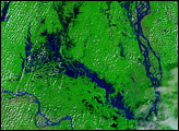
The Wayombo Rivier (Wayombo River) in Suriname exhibits a similar but slightly different flavor of unexpected behavior. The Boven Wayambo (loosely translated to “upper Wayambo”) splits and becomes the Wayombo—a river that runs over flat terrain and can flow either entirely west or east depending on circumstances, the researchers concluded.
The OLI-2 on Landsat 9 acquired this image (above) of the junction in September 2023. To the west, the Wayombo joins the Nickerie River, and to the east, it meets the Coppename. Both empty into the Atlantic Ocean.
Which way the Wayombo flows depends on natural and human factors, including precipitation and infrastructure. For example, a lock near the junction with the Nickerie helps draw water west to support rice cultivation near that river’s outlet. The Wayombo may otherwise run east toward the Coppename.
The SWOT (Surface Water and Ocean Topography) satellite mission—led by NASA and the Centre National d’Études Spatiales (CNES)—may aid in understanding the hydrological nuances of unusual waterways such as the Casiquiare and the Wayombo, the authors note. Since December 2022, SWOT has been measuring the height of nearly all water on Earth’s surface, developing one of the most detailed, comprehensive views yet of the planet’s ocean and freshwater lakes and rivers.
NASA Earth Observatory images by Wanmei Liang, using Landsat data from the U.S. Geological Survey. Story by Lindsey Doermann.